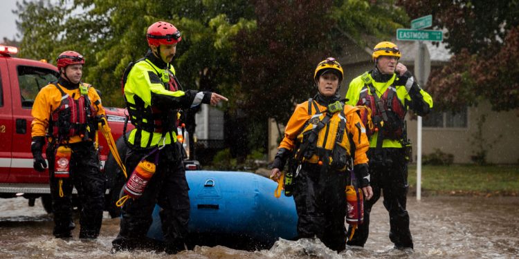
California bore the brunt on Sunday of what meteorologists referred to as a “bomb cyclone” and an “atmospheric river,” a convergence of storms that brought more than half a foot of rain to parts of the Bay Area, along with high winds, flash floods and the potential for heavy snow in the Sierra Nevada.
From Marin County to the area just south of Big Sur along the Pacific Coast, flash flood watches were in effect until late Sunday night and, in some areas, early Monday morning, including parts of the San Francisco Peninsula. The system is so vast that it was expected to reach southern British Columbia on Monday, where it was set to bring rain and strong winds, according to the National Weather Service in Seattle and Tacoma, Wash.
The threat of flash floods prompted evacuation orders for parts of San Mateo County, south of San Francisco. In San Francisco, emergency personnel ordered evacuations on one block where, they said, several structures were threatened by a tree that was leaning.
The convergence of storms comes at a challenging time for California, which has been besieged by wildfires and drought, the result of extreme weather brought on by climate change.
Images of a devastating landslide on Highway 70 in Plumas County showed a deluge of rocks and vegetation that had barreled down from a mountainside and blocked the highway.
The state authorities warned that areas with burn scars, where vegetation was at least partially eliminated by a fire, could see debris flows of rushing mud, rocks or vegetation that may sound, as they phrased it, like a freight train.
The California Governor’s Office of Emergency Services said on Twitter early Sunday that it was monitoring burn scars in Kern, Santa Cruz and El Dorado Counties. “Excessive rainfall” over El Dorado County’s burn scar, which was caused by the Caldor fire, could cause life-threatening flash floods, the National Weather Service in Sacramento said on Sunday morning.
As of 4:30 p.m. local time on Sunday, at least 147,000 utility customers in the Bay Area had lost power, said J.D. Guidi, a spokesman for Pacific Gas and Electric. More than half of those outages were reported on the San Francisco Peninsula and in Sonoma and Marin Counties.
Though Oregon and Washington hadn’t seen significant rainfall from the storm by Sunday evening, strong winds may be to blame for 185,000 power outages in Washington and at least 19,000 in Oregon, according to PowerOutage.US.
Parts of Washington experienced strong wind gusts, including Everett, about 25 miles north of Seattle, where gusts of up to 61 m.p.h. were recorded, according to the National Weather Service in Seattle. Winds were expected to increase on Sunday night, and remain gusty through Monday, the office said on Twitter.
“The atmospheric river is aiming a fire hose, if you will, into our area,” Sean Miller, a meteorologist for the Weather Service in Monterey, Calif., the forecast office for the Bay Area, said on Sunday.
An atmospheric river is a concentrated plume of moisture that extends over the ocean, typically in the troposphere, the lowest layer of the atmosphere, Mr. Miller said. The current trough was angled toward the North Bay, he said.
In the Pacific Northwest, a bomb cyclone, a type of storm known for its falling atmospheric pressure, was expected to push the atmospheric river south, affecting areas south of San Francisco, Mr. Miller said.
“This is more typical of something we tend to see in December or January,” he said, pointing out that the confluence of the two meteorological phenomena was “anomalous.”
The high winds and heavy rain prompted the authorities to close the sidewalks on the Golden Gate Bridge on Sunday. In the East Bay, organizers of the Alameda County Fair closed the event on Sunday because of the storm, while an Ironman triathlon scheduled for Sunday in Sacramento was canceled.
Alcatraz Island canceled all of its tours on Sunday, and the San Francisco and Oakland zoos and San Francisco’s golf courses were also shut.
Sunday night’s N.F.L. game between the San Francisco 49ers and the Indianapolis Colts at Levi’s Stadium in Santa Clara, however, went on as scheduled — albeit under heavy rain at times.
Throughout the day, the San Francisco Fire Department posted updates on Twitter about flooding, felled trees, fires, and stalled vehicles on flooded roadways.
The Santa Clara County Fire Department said on Sunday that it had responded to several vehicle accidents, downed wires, and felled trees throughout the afternoon.
In the city of Los Altos, about 17 northwest of San Jose, a tree fell on a passing vehicle, but no one was hurt, the department said on Twitter.
“Today is a great day to stay home,” the department said.
In Santa Rosa, about 55 miles north of San Francisco, roadways in parts of the city looked like streams. The city’s fire department said several creeks and streets were flooding, and urged residents to avoid travel.
By 4 p.m. local time, the Santa Rosa Fire Department said on Twitter that water levels had “significantly reduced,” but that road closings and evacuations would remain in effect until rainfall rates abated.
The deluge wasn’t limited to the Bay Area, as landslides and dangerous road conditions were reported in areas across Northern California. In Truckee, north of Lake Tahoe, the California Highway Patrol said on Twitter on Sunday afternoon that rocks and water had fallen down a mountainside, blocking a road.
On Tuesday, Gov. Gavin Newsom issued a proclamation extending California’s drought emergency statewide and asked residents to redouble their water conservation efforts. This has been California’s second driest year on record, with near-record low storage in the state’s largest reservoirs, the governor’s office said.
Severe drought conditions, worsened by climate change, continue to affect much of the Western United States and even the northern part of the Great Plains.
While droughts are not uncommon in the region, scientists say that climate change, in the form of warming temperatures and shifts in precipitation, is making the situation worse.
Source by www.nytimes.com


