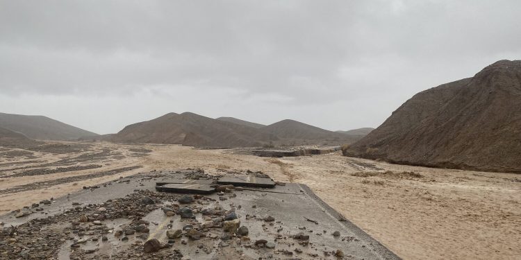
As Death Valley National Park gets ready to reopen its most popular sites on Saturday after heavy flooding, California national parks are still reeling from the aftermath.
After heavy rainfall caused flash flooding in the state’s mountains and deserts, Death Valley was forced to close all roads into the park on Aug. 5. The closure occurred after a historic storm wreaked havoc on the park, damaging 60 vehicles and trapping about 500 visitors and another 500 staff members.
“This was a 1,000-year flood event. It is quite possibly the most widespread catastrophic event in this park’s history,” said Ana Cholo, a Death Valley National Park spokesperson. “The park, which has approximately 1,400 miles of roads, including 200 miles of paved roadways, was affected by debris, shoulder road loss, undercutting and pavement loss.”
On Monday, the U.S. Department of Transportation provided the park with $11.7 million in emergency relief funding to repair damage from the flooding.
Workers have been able to assess 600 miles of roads, and 200 miles were deemed impassable, Cholo said. There are still 800 more miles of road to assess.
Cholo said the flood recovery efforts in the park are far from over. Across the park’s 3.4 million acres — 93% of which are designated as wilderness — only 42% of the roadways have been currently assessed. Park roads may remain closed for weeks and months, depending on the severity of the damage, Cholo said.
The sites that will open Saturday include the Furnace Creek Visitor Center, Golden Canyon, Artist Drive, Devils Golf Course, Natural Bridge, Zabriskie Point, Dantes View, Mesquite Sand Dunes, Twenty Mule Canyon and Harmony Borax Works.
The Badwater Basin will also reopen, but it will be accessible only from State Route 190 and will be closed at Mile Marker 17, Cholo said. State Route 190 had been scheduled to reopen Wednesday, but that was delayed to Saturday after authorities determined the road was not ready.
Cholo also warns that several park roads will remain closed, so visitors should plan ahead and not rely on navigation tools or GPS.
Joshua Tree National Park was also hit by a massive rainstorm Tuesday that was concentrated in the southern area. As of Wednesday morning, the Pinto Basin Road from Ocotillo to the south boundary, the Geology Tour Road from the northern gate to Berdoo Canyon, and the Big Horn Pass complex are all closed. It is unclear when the park plans to reopen these sites.
The southern side of Joshua Tree was previously evacuated, and roads closed when flooding hit Aug. 8.
All facilities on the northern side of the park remain open, according to a news release.
The park warns visitors to drive with caution to avoid debris in roadways. The park also notes that during wetter weather, tortoises are more likely to emerge and can appear like rocks in the road. Visitors are urged to drive slowly and help protect the federally threatened species.
The Mojave National Preserve is also grappling with persistent monsoons in the area. All of the preserve’s paved roads were closed for nearly two weeks because of flood damage in late July.
Currently, North Kelbaker Road remains closed because of a severe washout and will probably take months to repair, according to a news release. Zzyzx Road, which leads to the California State University Desert Studies Center, is also still closed because of severe undercutting of the pavement, a news release said.
Roads that have reopened in Mojave still have flood scars including debris overflows, steep shoulder drop-offs, and pavement erosion. Because of this, it is still dangerous to drive on the preserve, the news release said.
The monsoon season typically runs late July through mid-September, according to Dan Berc, a warning coordination meteorologist at the National Weather Service in Las Vegas, which monitors the weather at Mojave National Preserve and the Joshua Tree and Death Valley national parks. Although flooding due to the monsoon season is not unprecedented, it is “certainly historic and rare,” he said.
“In the last few years, we’ve had very dry monsoon seasons, but this year, we’ve had a lot of moisture up there and a lot of fuel for thunderstorms,” Berc said. “Any thunderstorms that form are very efficient rainers because they can really bring a lot of rain out of the atmosphere, especially when we’ve got this much moisture.”
He notes that thunderstorms over national parks are especially dangerous because they can dump a lot of rain over a short period of time, which leads to flooding.
Some thunderstorms are expected in the area over the next few days, but no major flooding is expected, Berc said. He added that he expects drier conditions starting early next week. There are no flash flood warnings or watches in effect.
“There will be isolated storms [Thursday] that could produce some heavy rain and maybe even a little flash flooding, but it won’t be widespread and it certainly won’t be like it was when we had the flooding in Death Valley,” Berc said.
Berc said that since it’s still monsoon season for about another month, there could still be another resurgence that leads to flooding. However, that level of flooding isn’t expected in the short term, he said.
Cholo said that Death Valley’s location is prone to summer rains and flash flooding. She adds that they will continue prioritizing safety.
“Every so often, there are events that are large enough to break weather records, like this one,” Cholo said. “Safety is our biggest concern, and these types of flash flooding events and monsoonal storms will be addressed with that in mind. Our top priority is to provide for the safety of all incident responders, park staff and visitors.”
Death Valley should expect temperatures in the mid-110s throughout the week, which is typical for this time of year. Joshua Tree is looking at temperatures in the low to mid-90s, which is also normal.
Source by www.latimes.com


